
GlobalCAD utilities for AutoCAD, утилиты для AutoCAD |
Здравствуйте, гость ( Вход | Регистрация )
| Here You Can Support Our Work and .:LavTeaM:. Services |
GlobalCAD utilities for AutoCAD, утилиты для AutoCAD |
| Гость_mavka_* |
 10.08.2006 - 17:29 10.08.2006 - 17:29
Сообщение
#1
|
|
Гость |
GlobalCAD
Оф. сайт: http://www.globalcad.com/
Сообщение отредактировал mavka - 10.08.2007 - 10:39 |

|

 
|
 |
|
20.04.2016 - 15:42
Сообщение
#2
|
|
 Торговец чёрным деревом  Группа: Админы Пользователь №: 3953 Сообщений: 22878 Регистрация: 1.08.2003 Из: Москва Загружено: байт Скачано: байт Коэффициент: --- Спасибо сказали: 62311 раз(а) |
GlobalCAD Landscape 2016 v1.2
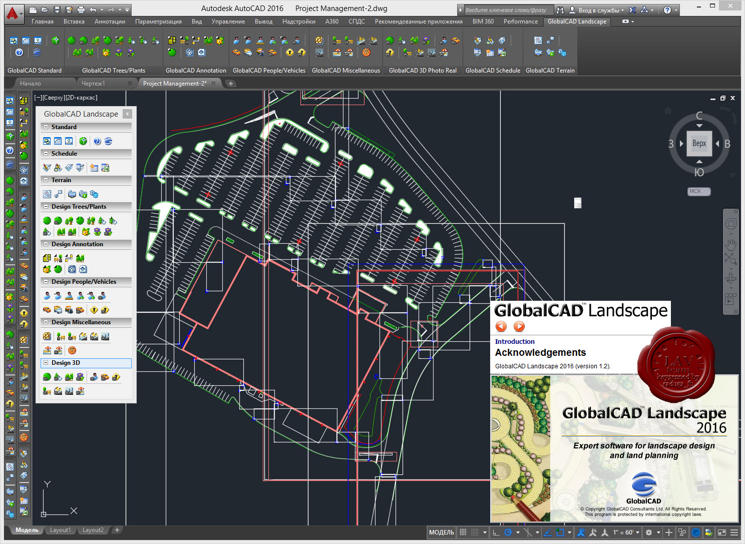 GlobalCAD Landscape is the integrated landscape design solution that simplifies the way you work with AutoCAD 2007-2016 and Bricscad 11-16. In today's competitive environment, GlobalCAD Landscape boosts productivity and helps you deliver winning designs ahead of time. Key Features: - Freedom to investigate design concepts with professional 2D symbol libraries. - Published in association with industry experts, design libraries are indexed into familiar categories, saving valuable drafting time. - Instant ribbon/toolbar access to symbols, hatch patterns and complex linetypes. - Create stunning presentations with an outstanding array of 3D models, featuring landscape GIS and civil. - All models are render-ready with applied materials for fast, effortless photorealistic results directly within AutoCAD/Bricscad. - Options also exist for seamless export to visualization packages such as Autodesk 3DS Max and AccuRender. - Browse and compare blocks and drawing details fast within libraries. - Create extensive libraries containing 2D, 3D and attributed blocks within seconds - with no user intervention necessary. - Generate surveys with ‘intelligent’ survey markers - for ultimate accuracy. - Move any markers in your drawing and their associative XYZ label automatically updates to reflect their new position! - Easily create 3D surface terrains (mesh and solids options) covering vast areas with a single mouse click. - Conversion tools to instantly transform any existing surface mesh to solids. - Quickly attach attribute and cost information to drawing objects and symbols. - Query drawings and export data to popular formats including MS Excel and Access. - Bi-directionally link drawings and corresponding spreadsheets. - The most complete reference with extensive data on over 10,000 plants. - Uniquely expandable, add your own plant data, photographs and more. More info: http://www.globalcad.com/products/landscape.html  + +  = link. = link.103 Mb (RAR5, incl. 3% - info for restoration purpose) |
|
|
|
 mavka GlobalCAD utilities for AutoCAD 10.08.2006 - 17:29
 kikoko GlobalCAD Schedule 2007
_http://www.globalcad.com/... 12.08.2006 - 18:43
kikoko GlobalCAD Schedule 2007
_http://www.globalcad.com/... 12.08.2006 - 18:43
 kserg Цитата(kikoko @ 12.08.2006 - 18:43) ... 27.09.2006 - 10:32 leba Цитата(kserg @ 27.09.2006 - 07:22) Ц... 1.11.2007 - 12:47 kikoko GlobalCAD Schedule 2008
+ Hidden textGlobalCAD 20... 20.06.2007 - 18:57 Serg_k А можно по-русски, что за прога ? 10.08.2007 - 06:41 mavka Serg_k
Добавил описание 10.08.2007 - 10:39 kserg _http://www.globalcad.com/downloads/GcadHm2008Tria... 20.08.2007 - 17:23 GaRRosiLLo keygen for hatch manager 2008? 29.10.2007 - 22:58 glukovod а кряк к ЛандАрку 2008 у кого нить есть???
ну или... 27.11.2007 - 14:12 graser У кого есть ToolBox LT под autocad 2009 LT с лекар... 17.03.2011 - 09:29 Bipsi Any chance for GlobalCAD Landscape 2013 29.10.2012 - 03:56 raduga_fb RE: GlobalCAD utilities for AutoCAD 29.10.2012 - 14:38 Bipsi Not working, blocks is not fully unlocked 29.10.2012 - 17:26 istigatore raduga_fb,
Please serial for globalCAD terrain 20... 29.10.2012 - 18:32 ahyakbaba QUOTE (istigatore @ 29.10.2012 - 18... 30.10.2012 - 10:01 raduga_fb You can use same serial number to install globalca... 30.10.2012 - 11:38 ismail full setups
CODEpart1: http://www.mediafir... 30.10.2012 - 11:51 Williams ismail, are they full versions? Or trial/demo with... 30.10.2012 - 22:42 ismail QUOTE (Williams @ 30.10.2012 - 21:42... 31.10.2012 - 09:17 Williams GlobalCAD Architecture 2016 v1.2
Компания Globa... 30.10.2012 - 23:05 Williams GlobalCAD Architecture 2013
Компания GlobalCAD ... 31.10.2012 - 18:13 Bipsi I have a problem with landscape terrain and acad 2... 31.10.2012 - 22:34 Williams GlobalCAD Landscape 2013 v1.2
GlobalCAD Landsca... 1.11.2012 - 21:45 christkill GlobalCAD Architecture 2013 non medicine in zip 5.11.2012 - 16:49 Williams GlobalCAD Exchange 2013 v1.2
GlobalCAD Exchange... 5.11.2012 - 19:30 Williams GlobalCAD Symbols Packs 1-4 2013
GlobalCAD Symb... 5.11.2012 - 21:59 endest Only 1 module can be installed at same time. 8.11.2012 - 04:00 Williams GlobalCAD Schedule 2013 v1.2
The essential tool... 18.11.2012 - 21:34 melshy i can't installed because i don't have ser... 24.11.2012 - 22:08 freeko GlobalCad AIO
It Includes all Global cad packages... 25.11.2012 - 12:06 Williams GlobalCAD Hatch Manager 2013 v1.2
Success in de... 2.02.2013 - 11:41 Williams GlobalCAD Organizer 2013 v1.2
GlobalCAD Organiz... 2.02.2013 - 12:08 Williams GlobalCAD Toolbox LT 2009
Toolbox LT is the rev... 3.02.2013 - 10:32 Bipsi Please, upload version 2014, thanks 29.09.2013 - 21:01 kikoko Info: Released new versions 2014 , some old keys s... 19.10.2013 - 08:07 Varlam Не видит Autocad 2014, есть ли какие-нибудь сообра... 5.11.2013 - 09:25 914mrx Hello, i have the same problem like post #24......... 14.01.2014 - 21:41 914mrx QUOTE (914mrx @ 14.01.2014 - 21:41) ... 20.05.2014 - 12:51 freeko GlobalCAD 2015 products is out 12.01.2015 - 14:44 Inge09 GlobalCAD Exchange 2015
GlobalCAD Schedule 2015... 13.01.2015 - 07:03 cretu Amazing work Williams.
All the best.
Regards,
C.A. 25.03.2015 - 19:41 freeko All 2015 is out
http://download.globalcad.com/Gca... 29.03.2015 - 12:31 loshlosh SORRY , you can only install a computer program ? 20.04.2015 - 08:22 amaraa6a GlobalCAD Architecture 2013
GlobalCAD Landscape 20... 19.07.2015 - 14:46 cadcamcae amaraa6a, the answer is in first post of this thre... 28.07.2015 - 13:23 Inge09 GlobalCAD 2016 Products:
QUOTE http://download.gl... 24.01.2016 - 09:33 Williams GlobalCAD Architecture 2016 v1.2
Компания Globa... 20.04.2016 - 15:16 Williams GlobalCAD Terrain 2016 v1.2
The essential tools... 21.04.2016 - 08:08 Williams GlobalCAD Symbols Packs 1-4 2016 v1.2
GlobalCAD... 21.04.2016 - 09:36 santorini Very nice programs but after installing one trying... 21.04.2016 - 09:46 dankocad use the same serial number for everybody apps? 21.04.2016 - 15:34 santorini Yes, the serial works for all. I found a solution ... 21.04.2016 - 16:36 istigatore RE: GlobalCAD utilities for AutoCAD 21.04.2016 - 17:26 912345678 Please give me old key:
- GlobalCAD Architecture
-... 23.04.2016 - 05:47 Williams GlobalCAD Organizer 2016 v1.2
GlobalCAD Organiz... 23.04.2016 - 10:01 Williams GlobalCAD Schedule 2016 v1.2
The essential tool... 24.04.2016 - 14:53 Williams GlobalCAD Hatch Manager 2016 v1.2
Success in de... 25.04.2016 - 08:52 omariana Thanks Mr Williams
Help:
Maybe someone knows how t... 26.04.2016 - 18:04 cadcamcae Yes, i have same problem, how to instal all addons... 25.06.2016 - 17:05 noni GlobalCAD 2017 Products:
http://download.globalca... 2.03.2017 - 19:40 Trog1 Hi everyone,
The 2018 versions of GlobalCAD are ou... 25.08.2017 - 19:23 GK.000 http://download.globalcad.com/GcadAr2018Trial.exe
... 25.08.2017 - 23:53 santorini Why Trial if you can full ?
CODEhttp://downlo... 26.08.2017 - 11:34 GK.000 ok .............. 26.08.2017 - 15:12 56roman добрый день
при установке globalcad(landsc)2018 по... 24.03.2018 - 14:26 noni Can anyone share the GlobalCAD Landscape 2018 inst... 31.08.2021 - 11:10 toforgive https://www.globalcad.com/downloads/GcadLs2018.exe... 1.02.2022 - 21:28 noni Большое СПАСИБО toforgive !!! 16.02.2022 - 20:22
kserg Цитата(kikoko @ 12.08.2006 - 18:43) ... 27.09.2006 - 10:32 leba Цитата(kserg @ 27.09.2006 - 07:22) Ц... 1.11.2007 - 12:47 kikoko GlobalCAD Schedule 2008
+ Hidden textGlobalCAD 20... 20.06.2007 - 18:57 Serg_k А можно по-русски, что за прога ? 10.08.2007 - 06:41 mavka Serg_k
Добавил описание 10.08.2007 - 10:39 kserg _http://www.globalcad.com/downloads/GcadHm2008Tria... 20.08.2007 - 17:23 GaRRosiLLo keygen for hatch manager 2008? 29.10.2007 - 22:58 glukovod а кряк к ЛандАрку 2008 у кого нить есть???
ну или... 27.11.2007 - 14:12 graser У кого есть ToolBox LT под autocad 2009 LT с лекар... 17.03.2011 - 09:29 Bipsi Any chance for GlobalCAD Landscape 2013 29.10.2012 - 03:56 raduga_fb RE: GlobalCAD utilities for AutoCAD 29.10.2012 - 14:38 Bipsi Not working, blocks is not fully unlocked 29.10.2012 - 17:26 istigatore raduga_fb,
Please serial for globalCAD terrain 20... 29.10.2012 - 18:32 ahyakbaba QUOTE (istigatore @ 29.10.2012 - 18... 30.10.2012 - 10:01 raduga_fb You can use same serial number to install globalca... 30.10.2012 - 11:38 ismail full setups
CODEpart1: http://www.mediafir... 30.10.2012 - 11:51 Williams ismail, are they full versions? Or trial/demo with... 30.10.2012 - 22:42 ismail QUOTE (Williams @ 30.10.2012 - 21:42... 31.10.2012 - 09:17 Williams GlobalCAD Architecture 2016 v1.2
Компания Globa... 30.10.2012 - 23:05 Williams GlobalCAD Architecture 2013
Компания GlobalCAD ... 31.10.2012 - 18:13 Bipsi I have a problem with landscape terrain and acad 2... 31.10.2012 - 22:34 Williams GlobalCAD Landscape 2013 v1.2
GlobalCAD Landsca... 1.11.2012 - 21:45 christkill GlobalCAD Architecture 2013 non medicine in zip 5.11.2012 - 16:49 Williams GlobalCAD Exchange 2013 v1.2
GlobalCAD Exchange... 5.11.2012 - 19:30 Williams GlobalCAD Symbols Packs 1-4 2013
GlobalCAD Symb... 5.11.2012 - 21:59 endest Only 1 module can be installed at same time. 8.11.2012 - 04:00 Williams GlobalCAD Schedule 2013 v1.2
The essential tool... 18.11.2012 - 21:34 melshy i can't installed because i don't have ser... 24.11.2012 - 22:08 freeko GlobalCad AIO
It Includes all Global cad packages... 25.11.2012 - 12:06 Williams GlobalCAD Hatch Manager 2013 v1.2
Success in de... 2.02.2013 - 11:41 Williams GlobalCAD Organizer 2013 v1.2
GlobalCAD Organiz... 2.02.2013 - 12:08 Williams GlobalCAD Toolbox LT 2009
Toolbox LT is the rev... 3.02.2013 - 10:32 Bipsi Please, upload version 2014, thanks 29.09.2013 - 21:01 kikoko Info: Released new versions 2014 , some old keys s... 19.10.2013 - 08:07 Varlam Не видит Autocad 2014, есть ли какие-нибудь сообра... 5.11.2013 - 09:25 914mrx Hello, i have the same problem like post #24......... 14.01.2014 - 21:41 914mrx QUOTE (914mrx @ 14.01.2014 - 21:41) ... 20.05.2014 - 12:51 freeko GlobalCAD 2015 products is out 12.01.2015 - 14:44 Inge09 GlobalCAD Exchange 2015
GlobalCAD Schedule 2015... 13.01.2015 - 07:03 cretu Amazing work Williams.
All the best.
Regards,
C.A. 25.03.2015 - 19:41 freeko All 2015 is out
http://download.globalcad.com/Gca... 29.03.2015 - 12:31 loshlosh SORRY , you can only install a computer program ? 20.04.2015 - 08:22 amaraa6a GlobalCAD Architecture 2013
GlobalCAD Landscape 20... 19.07.2015 - 14:46 cadcamcae amaraa6a, the answer is in first post of this thre... 28.07.2015 - 13:23 Inge09 GlobalCAD 2016 Products:
QUOTE http://download.gl... 24.01.2016 - 09:33 Williams GlobalCAD Architecture 2016 v1.2
Компания Globa... 20.04.2016 - 15:16 Williams GlobalCAD Terrain 2016 v1.2
The essential tools... 21.04.2016 - 08:08 Williams GlobalCAD Symbols Packs 1-4 2016 v1.2
GlobalCAD... 21.04.2016 - 09:36 santorini Very nice programs but after installing one trying... 21.04.2016 - 09:46 dankocad use the same serial number for everybody apps? 21.04.2016 - 15:34 santorini Yes, the serial works for all. I found a solution ... 21.04.2016 - 16:36 istigatore RE: GlobalCAD utilities for AutoCAD 21.04.2016 - 17:26 912345678 Please give me old key:
- GlobalCAD Architecture
-... 23.04.2016 - 05:47 Williams GlobalCAD Organizer 2016 v1.2
GlobalCAD Organiz... 23.04.2016 - 10:01 Williams GlobalCAD Schedule 2016 v1.2
The essential tool... 24.04.2016 - 14:53 Williams GlobalCAD Hatch Manager 2016 v1.2
Success in de... 25.04.2016 - 08:52 omariana Thanks Mr Williams
Help:
Maybe someone knows how t... 26.04.2016 - 18:04 cadcamcae Yes, i have same problem, how to instal all addons... 25.06.2016 - 17:05 noni GlobalCAD 2017 Products:
http://download.globalca... 2.03.2017 - 19:40 Trog1 Hi everyone,
The 2018 versions of GlobalCAD are ou... 25.08.2017 - 19:23 GK.000 http://download.globalcad.com/GcadAr2018Trial.exe
... 25.08.2017 - 23:53 santorini Why Trial if you can full ?
CODEhttp://downlo... 26.08.2017 - 11:34 GK.000 ok .............. 26.08.2017 - 15:12 56roman добрый день
при установке globalcad(landsc)2018 по... 24.03.2018 - 14:26 noni Can anyone share the GlobalCAD Landscape 2018 inst... 31.08.2021 - 11:10 toforgive https://www.globalcad.com/downloads/GcadLs2018.exe... 1.02.2022 - 21:28 noni Большое СПАСИБО toforgive !!! 16.02.2022 - 20:22 |

|
Текстовая версия | Сейчас: 15.08.2025 - 18:04 |


